Discover the Secrets of Chain of Craters Road
Active
2h
For a full refund, cancel at least 24 hours before the scheduled departure time.
Instant confirmation
Mobile or paper ticket accepted
About this experience
New Tour starting 2026! Give us 2.5 hours, and we will make you lava detectives! Learn about past eruption events, lava formations, and how they happened. This tour starts with a 1-mile hike from the edge of a pit crater to the lava tube. From there, we drive to the end of Chain of Craters Road as you have formations explained and narrated.
Learn more and see things you would never find on your own! Give us 3 hours, and you will learn much more about volcanoes, Hawaii's landscape, native plants, wildlife, and Hawaiian culture. We cannot show you the whole Park in only 3 hours, but we give you several stops to enrich your understanding and immerse your senses.
After your tour with us, all the formations on the Big Island and Hawaii will make sense.
* Dress code: LAYERS and raincoats; mountain weather can change 20 degrees. Closed-toe shoes recommended. *
Available options
Discover the Secrets of Chain of Craters Road
What's included
Private transportation
Bottled water
Air-conditioned vehicle
Detailed itinerary
1
Stop 1
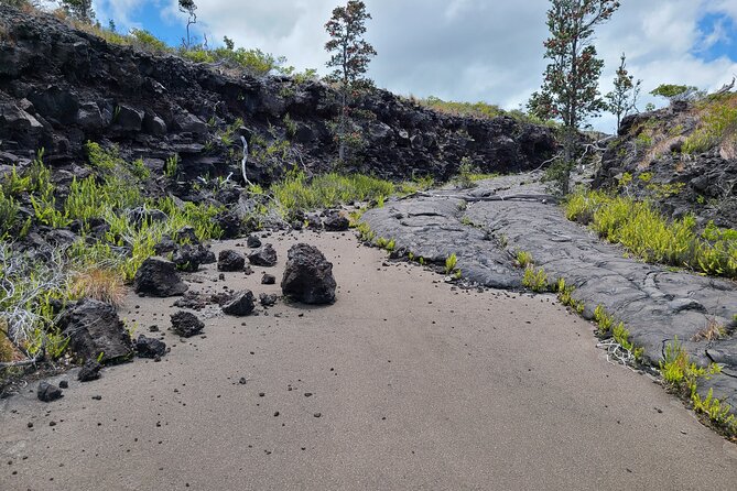
We are meeting at the Kilauea Iki Trailhead and will only hike half a mile on the trail to the lava tube. The total hike is just over one mile.
Name Meaning: Kīlauea Iki means “little Kīlauea” in Hawaiian — it’s a smaller crater right next to the main Kīlauea summit caldera.
Size: The crater is about a mile long, 3,000 feet wide, and the floor lies ~400 feet below the rim — big enough to house an entire lava lake!
The Legendary 1959 Eruption
Spectacular Lava Fountains: In 1959, Kīlauea Iki became one of the most dramatic eruptive sites of the 20th century, with lava fountains shooting up to 1,900 feet (580 m) into the sky.
Lava Lake Formation: Over several weeks of eruptions, molten lava filled the crater to form a deep lake — about 400 feet thick — one of the most studied lava lakes in history.
2
Stop 2
We walk along the edge of Kilauea Iki Crater to a 500-year-old lava tube in a temperate rainforest.
It’s a real lava tunnel formed when molten lava once flowed beneath the surface during a volcanic eruption. Once the liquid lava drained away, it left behind a hollow tube you can walk through.
The lava that carved out Nāhuku was over 2,000 °F (1,093 °C) while it flowed — crazy hot!
️
This lava tube is about 500 years old, geologically quite recent.
The tunnel you walk through is roughly 600 feet long and in some places the ceiling soars 20 feet high or more.
Rainforest Entrance
The trail to get into the tube winds through a lush native rainforest, alive with native birdsong and big ferns.
You’re literally going from jungle into the heart of what used to be a river of fire!
3
A July 1974 eruption partially filled in this crater as it oozed from vents nearby.
4
This area has a crater, but the most unusual feature of this area is the large thermal area that has killed trees and grass. The thermal area started around 1939, and it continues to slowly engulf the forest around it. We will have to wait and see what the future hold.
5
Mauna Ulu means “growing mountain” in Hawaiian — and the name is literal. It formed as a brand-new volcanic shield during a long-lasting eruption on Kīlauea’s East Rift Zone.
It isn’t a single cone, but a broad lava shield, built layer by layer as lava repeatedly spilled out and spread gently across the land.
A Historic Long-Lasting Eruption
Eruption dates: 1969–1974 — nearly five years, making it one of the longest eruptions of Kīlauea in modern history.
Over that time, Mauna Ulu erupted almost continuously, fundamentally reshaping the landscape along Chain of Craters Road.
6
Natural Sea Arch: Hōlei Sea Arch is a huge natural rock bridge formed by the relentless power of the Pacific Ocean eroding ancient lava cliffs. Waves slowly hollowed out softer and fractured parts of the basalt until an arch remained.
Size: The arch reaches roughly 90 feet (27 m) high — taller than a 7-story building!
Erosion at Work: The arch was carved from a lava flow that’s about 550 years old. Ocean waves pounded at cracks and weak spots between hard and soft lava layers — a process called differential erosion — gradually sculpting the arch you see today.
7
Pauahi comes from the Hawaiian words “pau” (finished/done) and “ahi” (fire), meaning “destroyed by fire” — a fitting name for a crater shaped by volcanic fire.
It’s a large volcanic pit crater — a deep, steep-sided depression formed mostly by the collapse of the surface as magma moves underground, rather than by explosive bombardment.
Pauahi is quite big: roughly 1,600–2,000 feet (about 500–610 m) long, up to about 300–500 feet (90–150 m) deep, and about 300 feet (90 m) wide.
Eruptive History
Pauahi has had multiple volcanic events in recent (geologic) history, making it more than just a static hole in the ground:
May 1973: A fissure opened and erupted briefly on the crater floor.
November 1973: A longer eruption (about 31 days) created lava flows and dramatic features on the crater floor.
November 1979: The most recent eruption was brief (one day) and left the lava surface you see today.
What's not included
Entrance to the National Park is $30/per car, it is good for 7 days.
Available languages
Guide guide
EN
Reviews breakdown
Viator
5.0
1 reviews
5★
1
4★
0
3★
0
2★
0
1★
0
Tripadvisor
5.0
1 reviews
5★
1
4★
0
3★
0
2★
0
1★
0
Important information
Suitable for all physical fitness levels
Meeting point
Kilauea Iki Trailhead in Hawaii Volcanoes National Park. Once you pass the Ranger Stations at the entrance, head towards the signs that say lava tube.
About Big Island of Hawaii
The Big Island of Hawaii is the largest and youngest of the Hawaiian Islands, known for its diverse landscapes, including snow-capped mountains, active volcanoes, and lush rainforests. It offers a unique blend of adventure, relaxation, and cultural experiences.
Top Attractions
Hawaii Volcanoes National Park
This national park is home to two active volcanoes, Kilauea and Mauna Loa. It offers hiking trails, scenic drives, and the opportunity to witness volcanic activity up close.
Nature/Adventure
Full day
Moderate ($30 per vehicle)
Mauna Kea Summit
Mauna Kea is the highest point in Hawaii and offers stunning views, stargazing opportunities, and a unique alpine environment.
Nature/Adventure
Half day to full day
Free (but requires acclimatization)
Waipio Valley
Waipio Valley is a lush, scenic valley known for its taro farms, waterfalls, and black sand beach. It is also a significant cultural site for Native Hawaiians.
Nature/Cultural
Half day
Free (but parking fee applies)
Hapuna Beach State Park
Hapuna Beach is one of the largest white sand beaches on the Big Island, offering swimming, snorkeling, and sunbathing opportunities.
Beach
Half day
Free (but parking fee applies)
Akaka Falls State Park
Akaka Falls is a stunning 442-foot waterfall surrounded by lush tropical vegetation. The park offers a scenic loop trail leading to the falls.
Nature
1-2 hours
Moderate ($5 per person)
Must-Try Local Dishes
Poke
A raw fish salad marinated in soy sauce, sesame oil, and green onions, often served with rice.
Appetizer
Contains fish, can be made with various types of seafood
Loco Moco
A hearty dish consisting of white rice topped with a hamburger patty, a fried egg, and brown gravy.
Main Course
Contains beef, eggs, and gluten (from the gravy)
Shave Ice
Finely shaved ice flavored with syrups and often topped with sweetened condensed milk or ice cream.
Dessert
Vegetarian, can be made with various toppings
Kona Coffee
A premium coffee grown in the Kona region, known for its rich and smooth flavor.
Drink
Caffeinated, can be decaffeinated
Popular Activities
Hiking
Volcano exploration
Water sports
Beach lounging
Spa treatments
Scenic drives
Traditional Hawaiian luaus
Local markets
Best Time to Visit
April to June, September to October
This is the best time to visit the Big Island, with pleasant weather and fewer tourists. The ocean is warm, and the weather is generally dry and sunny.
21-30°C
70-86°F
Practical Information
Language
- Official: English
- Widely spoken: Hawaiian, Japanese, Tagalog
- English: Widely spoken
Currency
US Dollar (USD)
Time Zone
Hawaii-Aleutian Standard Time (HST, GMT-10:00)
Electricity
120VV, 60HzHz
Safety Information
Overall Safety Rating: Generally safe
The Big Island is generally safe for travelers, with low crime rates and a welcoming atmosphere. However, visitors should be aware of natural hazards such as volcanic activity and ocean conditions.
Important Precautions:
- • Rent a car with full insurance coverage
- • Be cautious when purchasing souvenirs and tours, and research options in advance
- • Be aware of ocean conditions and currents when swimming and snorkeling
Getting there
By air
- Kona International Airport • 20 km from Kona
- Hilo International Airport • 10 km from Hilo
By bus
Hilo, Kona
Getting around
Public transport
The Hele-On Bus is the public bus system on the Big Island. It is affordable but has limited routes and schedules.
Taxis
Available • Apps: Uber, Lyft
Rentals
Car, Bike, Scooter
Neighborhoods
Kona
Hilo
Waimea
Day trips
Mauna Kea Summit
30 km from Waimea • Half day to full day
Mauna Kea is the highest point in Hawaii and offers stunning views, stargazing opportunities, and a unique alpine environment.
Waipio Valley
60 km from Hilo • Half day
Waipio Valley is a lush, scenic valley known for its taro farms, waterfalls, and black sand beach. It is also a significant cultural site for Native Hawaiians.
Hapuna Beach State Park
30 km from Waimea • Half day
Hapuna Beach is one of the largest white sand beaches on the Big Island, offering swimming, snorkeling, and sunbathing opportunities.
Festivals
Merrie Monarch Festival • April
Kona Coffee Cultural Festival • November
Ironman World Championship • October
Pro tips
- Rent a car to explore the island at your own pace and access remote areas
- Visit Hawaii Volcanoes National Park early in the day to avoid crowds and see the best views
- Pack layers, as temperatures can vary significantly depending on the elevation and location
- Try local dishes like poke, loco moco, and shave ice for an authentic taste of the Big Island
- Respect the environment and local culture, and follow guidelines for visiting protected areas and sacred sites
Get Price
per person
Price varies by option
Secure booking
Free cancellation available
Instant confirmation